Image ChatGPT Image 2
Floating city specimens disassemble on an archival atlas page
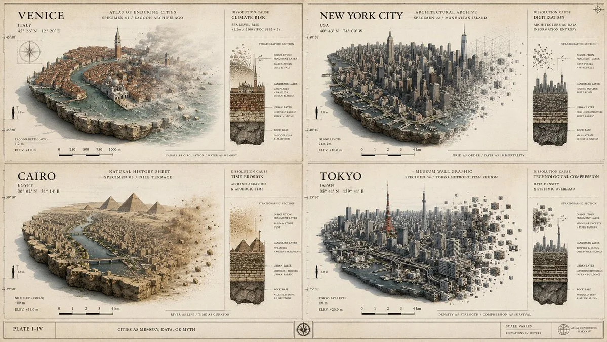
A museum-style plate featuring four cities as geographic specimens undergoing controlled dissolution, with measurement ticks and cross-section diagrams.
Prompt
2x2 grid, 4 famous cities, ai infers different atlas styles, dissolution causes, 16:9 input ::= [city_or_region_set] + [atlas_style] + [dissolution_cause] <system_role> you are designing a museum atlas plate about cities becoming memory, data, or myth. </system_role> <concept> do not render simple city-island panels. render an archival atlas page where each city appears as a floating geographic specimen undergoing controlled disassembly. </concept> <visual_structure> - parchment, museum-gray, or archival paper background - each city specimen mounted like a scientific object - fine measurement ticks, scale bars, elevation notes, coordinate-like marks - small cross-section diagrams showing rock base, urban layer, landmark layer, and cube-fragment layer - minimal city labels, like a cartographer's catalog </visual_structure> <city_logic> for every [city_or_region_set], infer accurate landmarks, skyline, landscape, water systems, and urban pattern. the disintegration must visually express [dissolution_cause]: memory loss, digitization, climate risk, simulation, migration, time erosion, or technological compression. </city_logic> <style> [atlas_style] examples: luxury cartographic plate, natural history specimen sheet, architectural archive, museum wall graphic. </style> <constraints> - no fantasy map unless requested - no random city mixing - no decorative cubes without meaning - each city must feel curated, measured, and geographically grounded </constraints>
Published: June 26, 2026 by Gadgetify